
Product Description
The Slingsby Overberg Whale Coast Digital Map map presents an attractive, double-sided layout featuring detailed street and area maps. It depicts relief using elevation tinting, spot heights, and 100-meter contour intervals. The map includes a variety of roads—from minor gravel and private roads to mountain passes—along with intermediate driving distances. Moreover, it clearly indicates routes that are particularly scenic or should be avoided. It also marks railways with local stations.
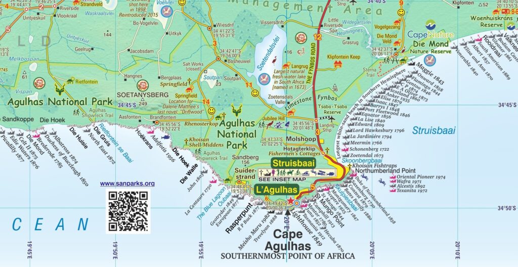
Side one extends from Somerset West along the coast to Cape Hangklip. It continues from Hermanus to Cape Agulhas and on eastwards to Port Beaufort/Witsand and the Breede River. Then the map goes north to Heidelberg, Barrydale and Montagu. From Robertson, it extends west to Villiersdorp and back to Stellenbosch. This detailed Slingsby Overberg Whale Coast Digital Map covers a diverse range of locations along this scenic route.
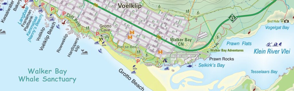
Side two includes enlarged inset maps of 24 of the larger towns in the region. These are at the greatly-enlarged scale of 1:25 000, or 4cm to the kilometre.
Extensive Features and Symbols
The Slingsby Overberg Whale Coast Digital Map uses symbols to represent a wide range of features. These include accommodation and camping sites, farm stalls and local produce shops like cheese, fish, and olives. Additionally, it highlights wine cellars, breweries, and outdoor recreation areas such as golf and paragliding. It also highlights landmarks, monuments, nature reserves, wildlife watching spots, botanical attractions, and wheelchair-friendly routes. Latitude and longitude lines appear at five-minute intervals for precise navigation.
Coastal Highlights and Marine History
A special focus on coastal areas enhances the Overberg Whale Coast Touring Paper Map. It includes details of the best beaches, yachting, diving, board sailing, and angling spots. Furthermore, it identifies prime whale-watching locations and numerous historic shipwreck sites, some dating back to the 17th century. If you’re exploring these areas, having the Slingsby Overberg Whale Coast Digital Map at hand can enrich your journey with precise directions and locations.
Insets and Additional Information
Inset maps at a 1:25,000 scale or larger surround the main map and appear on the reverse side. These detailed enlargements cover 25 towns and localities—including Hermanus, Bredasdorp, Betty’s Bay, Gansbaai, Kleinmond, Montagu, and Swellendam. These maps show relief, accommodations, petrol stations, and other facilities. The Overberg Whale Coast Touring Digital Map also provides contact details for further tourist information. In this comprehensive Slingsby Overberg Whale Coast Digital Map, you’ll find everything you need for an informed trip.
Key Features:
- Covers the whole of the official Overberg Tourism Region.
- We have based our detailed and beautifully drawn street maps on the latest available data to ensure accuracy.
- To help you navigate with ease, we show all roads—from major National Highways to minor gravel paths. These routes come complete with accurate distance markings.
- In addition, we provide full GPS coordinates in DD MM SS format for every road junction. This allows you to pinpoint your location precisely.
- To enhance your journey, we use smiley icons to highlight the most scenic routes across the country on our Slingsby Overberg Whale Coast Paper Map.
- Moreover, we feature over 30 different types of attractions. These include farm stalls, abseiling, horse riding, golf courses, game viewing, botanical gardens, and historical sites.
- You will also find a wide selection of accommodation options, especially in off-the-beaten-path areas.
- For nature lovers, we pinpoint the best whale-watching spots and over 200 historic shipwreck sites along the coastline.
- Finally, to enrich your cultural experience, we include a unique key explaining the meanings of Khoisan place names throughout the region. Keep the Slingsby Overberg Whale Coast Digital Map with you to deepen your understanding of these areas.
How to Download Your Digital Maps
We supply our digital maps in 300 dpi JPG format, packaged as a single ZIP file (110 MB). Please be patient—large files take time to load.
After you complete checkout or send proof of EFT payment, you will automatically receive an email with download instructions. The JPG files are not password protected, so access is simple. Especially when accessing the Slingsby Overberg Whale Coast Digital Map, simplicity is key.
You may download each purchased ZIP file of our Day Drives from Cape Town Digital Map a maximum of two times.
Important Notes on Using Our Digital Maps
- Our digital maps are snapshots of our paper maps. They are not interactive—enlarging them or removing elements (e.g., title pane) does not reveal more mapped area. However, you can enlarge or reduce them within their 300 dpi resolution.
- iPhone users: Some iPhones store images in the Cloud, requiring downloads each time you access a map. To avoid this, consider installing a flash memory card so maps remain immediately available, even in areas without Wi-Fi or phone reception. This issue appears uncommon on Android devices, but user feedback is appreciated.
- Recommendation: Download your digital maps to a laptop or other hard drive before transferring them to a tablet or smartphone.
- Important: Digital products are non-returnable. Once delivered, we cannot verify whether files have been fully deleted from your devices—please understand and be fair.


Reviews
There are no reviews yet.