
Product Description
The Cape Peninsula Touring Digital Map is the most up-to-date version of our famous Cape Peninsula map in digital format.
How to Download Your Digital Maps
We supply our digital maps in 300 dpi JPG format, packaged as a single ZIP file (35 MB). Please be patient—large files take time to load.
After you complete checkout or send proof of EFT payment, you will automatically receive an email with download instructions. The JPG files are not password protected, so access is simple.
You may download each purchased ZIP file a maximum of two times.
Important Notes on Using Our Digital Maps
- Our digital maps are snapshots of our paper maps. They are not interactive—enlarging them or removing elements (e.g., title pane) does not reveal more mapped area. However, you can enlarge or reduce them within their 300 dpi resolution.
- iPhone users: Some iPhones store images in the Cloud, requiring downloads each time you access a map. To avoid this, consider installing a flash memory card so maps remain immediately available, even in areas without Wi-Fi or phone reception. This issue appears uncommon on Android devices, but user feedback is appreciated.
- Recommendation: Download your digital maps to a laptop or other hard drive before transferring them to a tablet or smartphone.
- Important: Digital products are non-returnable. Once delivered, we cannot verify whether files have been fully deleted from your devices—please understand and be fair.
Key Features:
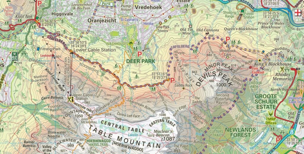
- Highlight the distinctive Table Mountain National Park with colour-shading and 20m contour intervals.
- Map and name all southern suburbs of Cape Town, including main roads, railways, and footpaths.
- Key more than 30 types of facilities, from theatres and restaurants to mountain biking and whale-watching.
- Name, list, and key over 500 places of special interest across the map.
- Detail built-up areas, industrial zones, informal settlements, cemeteries, sports grounds, shopping centres, cultivated lands, schools, police stations, and post offices.
- Offer the most detailed and up-to-date map of the Cape Peninsula available.
- Provide a comprehensive list of attractions keyed directly to the map.
- Include an inset map of Robben Island for added convenience.
Explore the Cape Peninsula
Explore the Cape Peninsula with this convenient A2-size, double-sided map at a scale of 1:50,000. It clearly presents topography, the road network, hiking trails, GPS waypoints, and numerous places of interest.
Wide Coverage
The map extends north beyond central Cape Town into the city’s northern districts. Moreover, it includes an inset map of Robben Island for added detail.
Detailed Road and Rail Networks
The map highlights main and secondary roads with driving distances, marks restricted access routes, and notes smaller local roads. In addition, it annotates many junctions and key locations with GPS waypoints. Railway lines and stations are also shown.
Hiking Trails and Attractions
Discover numerous hiking trails and easily locate beaches, diving spots, birdwatching sites, wineries, and other recreational areas. Clear symbols guide you to each attraction.
Clear Relief Presentation
Relief stands out through 20m contour intervals, hill shading, altitude colouring, and spot heights. This combination ensures excellent visibility of the region’s unique landscape.
User-Friendly Index
Finally, the map features an index organised by activity and attraction type, allowing you to quickly find exactly what you need.

Reviews
There are no reviews yet.