
Product Overview
Stay on track and stay connected while capturing every adventure with the Garmin Montana 760i GPS. Equipped with advanced outdoor features, it combines technology for two-way messaging and interactive SOS alerts, while the built-in 8MP camera documents your journey. Plus, its rugged 5-inch handheld design supports navigation on foot, bike, kayak, ATV, and beyond.
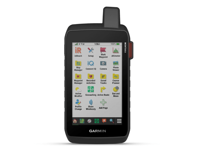
- navigate effortlessly using the large, 5-inch glove-friendly touchscreen
- explore confidently with preloaded, routable topographic maps highlighting key landmarks
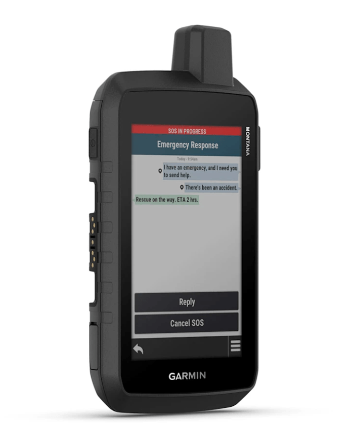
- stay connected through inReach® messaging and 24/7 SOS support
- capture memories with the built-in camera and tag locations for easy reference
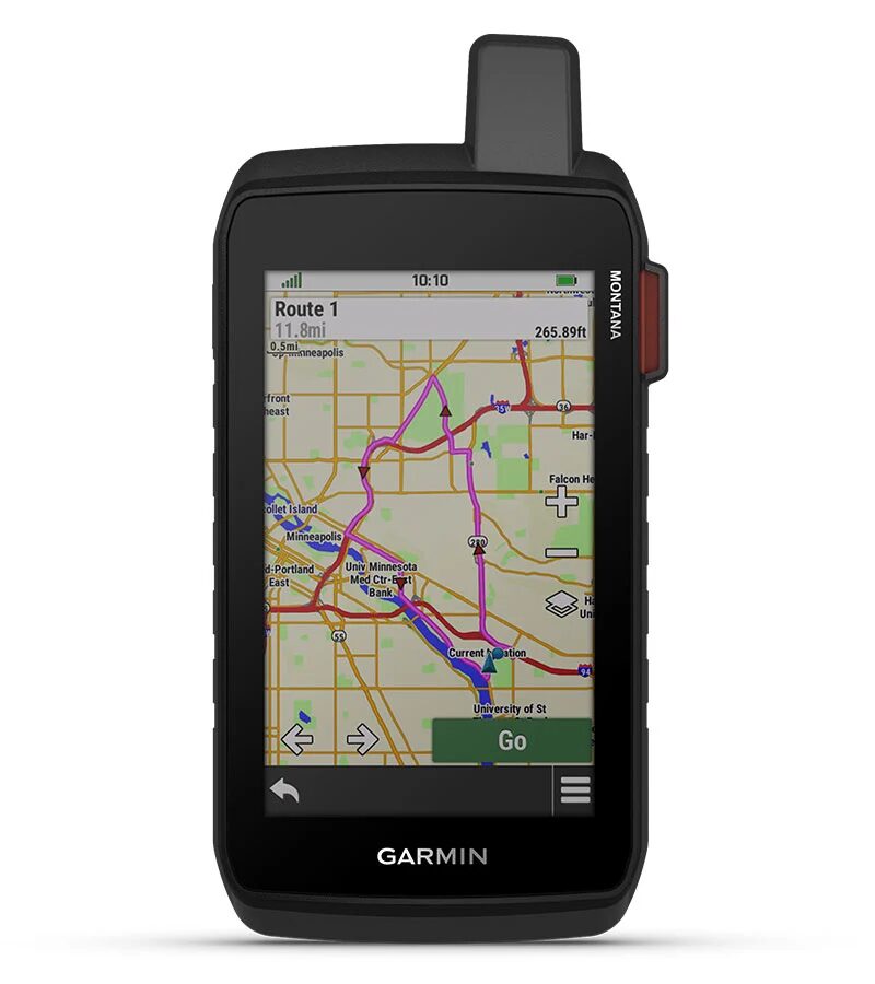
- view vivid overhead routes and terrain using high-resolution satellite imagery
Note: Tracks4Africa GPS Maps are NOT included.
NOTE: The Garmin Montana 760i GPS is usually delivered within 7 to 10 working days.
2 Year Warranty.
Please Note: For latest product details refer to garmin.com. Note that Garmin products are only for sale in South Africa. For warranty and returns see our Cancellation and Returns Policy.
The Garmin Montana 760i GPS is a dedicated GPS device, so it doesn’t use a standard OS like Windows or macOS. Instead, it runs a specialized proprietary system providing a tailored interface, apps, and features. These are designed specifically for navigation, route planning, and mapping. With the Garmin Montana 710, navigating is a seamless experience.
GLOBAL CONNECTIVITY

With an active inReach® subscription, stay connected even off-grid. Instead of relying on smartphone coverage, send messages, trigger SOS alerts, and share tracking through the 100% global Iridium® satellite network.
SATELLITE VIEWS

Access subscription-free, high-resolution satellite imagery via direct-to-device Wi-Fi® downloads. View photorealistic overhead routes and terrain, and quickly create waypoints using landmarks for easier navigation.
OUTDOOR MAPS+

Enhance your navigation by adding an Outdoor Maps+ subscription (sold separately), which provides ongoing access to premium mapping content and delivers regular updates directly to your Garmin device via Wi-Fi.
TOPOACTIVE MAPS

Easily navigate your adventures with preloaded topographical maps on the Garmin Montana 760i GPS, and seamlessly view terrain contours, elevations, rivers, coastlines, landmarks, and more for a complete outdoor experience.
RUGGED BY DESIGN
Designed for rugged adventures, this durable, water-resistant handheld not only meets MIL-STD 810 standards for thermal, shock, water, and vibration, but also features a glove-friendly 5-inch touchscreen. Furthermore, with versatile mounts (sold separately), you can confidently navigate, adapt, and rely on it across all your outdoor activities, whether hiking, biking, or exploring off-road.
BUILT-IN CAMERA

Capture every adventure with the Garmin Montana 760i GPS using its integrated 8MP autofocus camera. Additionally, it automatically geotags your photos, allowing you to easily navigate back to favorite spots and effortlessly relive your experiences.
INREACH FEATURES
- exchange text messages with loved ones or communicate directly between inReach® devices in the field
- trigger an interactive SOS to Garmin Response℠, a 24/7 professional emergency coordination center, in case of emergencies
- receive detailed inReach® weather forecasts directly on your Montana handheld or paired devices to plan ahead
- share your progress through live tracking, allowing followers to view your GPS location, ping your device, and exchange messages during your trip
NAVIGATION FEATURES
- pair with the Garmin Explore™ app to plan trips, review data, and manage waypoints, courses, and activities
- access GPS and Galileo satellite networks for reliable tracking in challenging environments
- navigate trails with ABC sensors: altimeter for elevation, barometer for weather, and 3-axis electronic compass
- transition seamlessly from trails to roads with preloaded New Zealand City Navigator® maps offering turn-by-turn directions
- expand mapping with 32 GB onboard memory for additional maps, including BlueChart® g3 charts for water navigation (sold separately)
- stay informed with up-to-date active weather forecasts via the Garmin Connect™ app
- track sporting dogs in the field by syncing with compatible Astro® or Alpha® series handhelds
- explore hiking, cycling, and other trails using the preloaded Wikiloc app, including a free 60-day Wikiloc Premium trial
ADVENTURE FEATURES
- trek off-grid with expedition mode, using ultralow-powered GPS to track for over 2 weeks between charges
- power your adventures with an internal lithium-ion battery offering up to 24 hours in GPS mode, rechargeable via standard USB-C®
- adapt your navigator for ATVs, boats, cars, motorcycles, motorhomes, and more with compatible vehicle mounts (sold separately)


 Products
Reviews
There are no reviews yet.