Product Description
Explore the Northern KZN Drakensberg with our Slingsby Drakensberg North Hiking Digital Map.
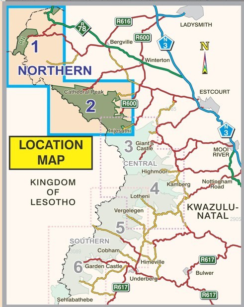
The map covers the stretch from Mpokelana through Royal Natal to the dramatic Mnweni area. The Slingsby Drakensberg North Hiking Digital Map is ideal for this region.
Meanwhile, it also highlights the ever-popular section of the Maloti-Drakensberg Park, including Cathedral Peak, Didima, Monk’s Cowl, and Injesuthi.
Built on Decades of Exploration
Over many years, experts collected data that shaped this first-ever recreational map of the northern KZN Drakensberg. The Slingsby Drakensberg North Hiking Digital Map was originally conceived in the mid-1970s, and has since evolved into a trusted companion for explorers.
Updated for Accuracy and Adventure
In this latest edition of our Drakensberg North Hiking Digital Map, we’ve geo-referenced all approved routes with precision, marked coordinates and elevations for every path junction, and added difficulty ratings for escarpment passes. Moreover, we’ve included many extra details that make Slingsby maps stand out for accuracy and adventure planning.
Why Choose Slingsby Maps?
Because every update enhances clarity, accuracy, and usability—making these maps, like the Slingsby Drakensberg North Hiking Digital Map, unbeatable for planning and navigating your adventure.
Key Features:
- Geo-referenced all approved routes with precision
- Marked coordinates and heights of every path junction
- Added difficulty ratings for escarpment passes
- Packed in a host of extra details that set Slingsby maps apart
- Finally, we secure credibility as the map is endorsed by Ezemvelo KwaZulu-Natal Wildlife.
How to Download Your Digital Maps
We supply our digital maps in 300 dpi JPG format, packaged as a single ZIP file (125 MB). Please be patient—large files take time to load.
After you complete checkout or send proof of EFT payment, you will automatically receive an email with download instructions. The JPG files are not password protected, so access is simple. Especially when accessing the Swartberg & Klein-Karoo Touring Digital Map, simplicity is key for accessing South Africa’s captivating region.
You may download each purchased ZIP file of our Day Drives from Cape Town Digital Map a maximum of two times.
Important Notes on Using Our Digital Maps
- Our digital maps are snapshots of our paper maps. They are not interactive—enlarging them or removing elements (e.g., title pane) does not reveal more mapped area. However, you can enlarge or reduce them within their 300 dpi resolution.
- iPhone users: Some iPhones store images in the Cloud. This requires downloads each time you access a map. To avoid this, consider installing a flash memory card so maps remain immediately available, even in areas without Wi-Fi or phone reception. This issue appears uncommon on Android devices, but user feedback is appreciated.
- Recommendation: Download your digital maps to a laptop or other hard drive before transferring them to a tablet or smartphone.
- Important: Digital products are non-returnable. Once delivered, we cannot verify whether files have been fully deleted from your devices—please understand and be fair.


 Products
Reviews
There are no reviews yet.